
Thomas Houet
LETG-Rennes COSTEL - UM5 6554 CNRS
Université Rennes 2, Place du recteur Henri Le Moal - 35043 Rennes Cedex
@ : thomas.houet[at]univ-rennes2.fr (thomas[dot]houet[at]univ-rennes2[dot]fr)
https://www.researchgate.net/profile/Thomas_Houet/
http://scholar.google.fr/citations?user=mDvRuMIAAAAJ&hl=fr
Directeur de Recherche CNRS
Thèmes de recherche
- Modélisation prospective
- Analyse des changements d'occupation et d’usages des sols
- Géomatique et télédétection par Drone
- Évaluation environnementale
- Paysages
Responsabilités
2023 - 2025 : Membre de la CID52 du CoNRS
2021 - 2025 : Membre de la Section 39 du CoNRS
2023 - ... : Directeur de la Zone Atelier Armorique (https://osur.univ-rennes1.fr/za-armorique/)
2018 - 2023 : Directeur-Adjoint de la Zone Atelier Armorique (https://osur.univ-rennes1.fr/za-armorique/)
2019 - ... : Responsable de la plateforme D2T (Drone, Terrain et Télédétection) (http://letg.cnrs.fr/article1262.html)
2019 - 2021: Responsable de la Commission Recherche de l'OSUR
2016 - 2018 : Membre élu du Conseil de l'OSUR
2016 - 2018 : Coordinateur scientifique de KALIDEOS Bretagne (https://bretagne.kalideos.fr/drupal/)
2016 - 2018 : Membre du comité d'animation de la Zone Atelier Armorique (http://osur.univ-rennes1.fr/za-armorique/)
Biographie synthétique
Thomas Houet est directeur de recherche au CNRS, basé à l'Université de Rennes depuis 2016. Il a passé 9 ans au sein du laboratoire GEODE (Géographie de l’Environnement) à Toulouse (2007-2016) en tant que chargé de recherche CNRS. Ses travaux portent sur le Land Change Science, avec une expertise en télédétection par drone, en modélisation des changements d'occupation et d'usage du sol et sur la construction de scénarios prospectifs de façon participative. Ses travaux visent à apporter et transférer des connaissances aux acteurs et décideurs afin de favoriser une transition vers un développement durable des territoires. Il a travaillé sur divers contextes géographiques tels que divers paysages agricoles, l'urbanisation et des territoires de montagne et sur les questions environnementales qui y sont liées. La majeure partie de ses travaux ont été réalisés dans le cadre de dispositifs scientifiques d’Observation des usages anthropiques et de leurs impacts sur l’environnement.
Cursus
2017- ... : Directeur de Recherche - 2ème classe CNRS - LETG UMR 6554 CNRS
2016-2017 : Chargé de Recherche 1ère classe CNRS – LETG UMR 6554 CNRS
2011-2016 : Chargé de Recherche 1ère classe CNRS – GEODE UMR 5602 CNRS
2007-2011: Chargé de Recherche 2ème classe CNRS – GEODE UMR 5602 CNRS
2006-2007: ATER Université Rennes 2
2002-2006 : Doctorat en Géographie – Université Rennes 2
Diplômes
2015 - Habilitation à diriger des recherches (Institut National Polytechnique de Toulouse)
Prospective environnementale et géographie : Apports de la dimension spatiale (pdf)
2006 – Doctorat de Géographie (Université de Rennes 2)
Occupation des sols et gestion de l’eau : Modélisation prospective en paysage agricole fragmenté (Application au SAGE Blavet) (pdf)
Distinctions
2019 - Aide à l'équipement Scientifique Rennes Métropole
2017 - Aide à l'Installation Scientifique Rennes Métropole (https://vimeo.com/257503074)
2016 - PEDR CNRS
2012 - PES CNRS
Programmes de recherche (sélection)
2025 - 2026 ANR Science Avec et Pour la Société - Projet PERFECTAE Participation et Échanges Ruraux de Foncier : Expérimentation Collective pour la Transition AgroÉcologique (Dir. T. Houet / T. Fouqueray)
2023 - 2028 PEPR FairCarbon - Projet Ciblé SLAM-B : Scenario and Labs and integrated Assessment Modelling for Bioeconomy (Dir. O Thérond)
2023 - 2027 ANR STRANGE - Ecosystem Services provided by sTReams to AdjaceNt aGricultural tErestrial ecosystems - Financeur ANR (Dir. C. Piscart / B. Bergerot)
2019-2022 ITN Marie Curie H2020 - TERRANOVA ‘The European Landscape Learning Initiative: Past and Future Environments and Energy Regimes shaping Policy Tools’ - Financeur : ERC (Dir. S. Kluiving, Univ. Amsterdam Netherlands)
https://terranovaproject.vu.nl/
2016-2019 Interreg Atlantic ALICE - Towards a better management of Atlantic Landscapes: developing tools to characterise bIodiversity and eCosystem sErvices - Financeur : UE Interreg (Dir. J. Barquin, IHC Spain)
http://project-alice.com/alice-project/
2010-2015 - Modélisation rétrospective et prospective des changements d’occupation des sols dans les Pyrénées (MODE RESPYR) - Dir. T. Houet (CNRS), Financeur: ANR JCJC
Encadrement de post-docs (sélection)
FOUQUERAY Timothée, 2023-2024 (18 mois) – Fondation CNRS - Evaluation des outils de gestion foncière pour une transition agroécologique de territoires agricoles intensifs : une approche prospective couplant modélisation spatiale et droit de l’environnement (IODE / LETG-Rennes) - Aujourd'hui McF à l'ENS Rennes
PALKA Gaetan, 2019-2021 (12 + 18 mois) - Projet Interreg ALICE. Développement et amélioration du modèle FORESCEM pour la simulation des changements d'occupation et d'usage des sols sur les paysages Atlantiques. - Aujourd'hui McF à l'Université d'Orléans
Thèses soutenues (sélection)
ERUDEL Thierry, 2014-2018 - Caractérisation de la biodiversité végétale en milieu montagnard et de piedmont par télédétection : apport des données hyperspectrales et lidar. Dir. X. Briottet (70%) / T Houet (30%), Thèse de Traitement de l'image, Institut supérieur de l'aéronautique et de l'espace (Toulouse) –Soutenue le 12 octobre 2018.
GRIMALDI Juliette, 2014-2018 – Apports de l’agroforesterie face à l’aléa climatique en viticulture : cas du microclimat en agroforesterie viticole dans le sud de la France. Thèse en surfaces et interfaces continentales, hydrologie, Dir. V. Bustillo (50%) / T. Houet (50%), Université Paul Sabatier (Toulouse) – Soutenue le 5 octobre 2018. pdf
ALVAREZ Emilien, 2018-2021 – Complémentarités des données produites par drone et satellites pour l’observation de la Terre : changements d’échelles et applications en écologie spatiale Thèse de géographie, Dir. T. Houet / T. Corpetti, Université Rennes. Soutenue le 25/10/2021 pdf
RIGO Roberta, 2019-2022 - Evaluating the usefulness of long-term landscape changes (over the past and the future) on the decision-making process, Thèse de Géographie, Dir. T. Houet, Co-Dir: P. Verburg. Soutenue le 5 mai 2023 pdf
Thèses en cours
BOISSONNAT Jean-Baptiste, 2023-2026 - Apports des données drones pour la conservation des landes Bretonnes (sèches oligotrophes), Thèse de Géographie, Université de Rennes 2 / Rennes 1, Dir. T. Houet, Co-Dir: F. Binet
DELABROSSE Augustin, 2024-2027 - Cartographie de la biodiversité émergente par télédétection multisources (drone) et intelligence artificielle, Thèse de Géographie, Université de Rennes 2, Dir. T. Houet, Co-Dir: T. Corpetti
CRETI Inès, 2024-2027 - Approche eTHnographique et prospective des changements d’Occupation et d’usage du Sol : observer et agir pour favoriser la transition agroécologique, Thèse de Géographie, Université de Rennes 2, Dir. T. Houet, Co-Dir: A. Sourdril
Enseignements
Mon activité d’enseignement se concentre sur les Universités de Toulouse et de Rennes, ainsi qu'au sein des écoles polytechnique de Toulouse et d’agronomie de Paris-Grignon. Il s’agit principalement d’interventions en Master 2 visant à promouvoir, diffuser et initier aux méthodes de la modélisation prospective spatialisée.
Formations
Organisation de l’école thématique SCEMSITE « SCEnarisations, Modélisations et SImulations spatialisées pour le Territoire », Puy, Saint-Vincent 3-11 mars 2016.
https://scemsite2016.sciencesconf.org/
Communication / Vulgarisation
Projet d'éducation au développement durable Zone Atelier Armorique / Ecole primaire Ercé-près-Liffré
Guest-éditeur de numéros spéciaux
Kozak J., Gimmi U., Houet T. & Bolliger J. (2017) Current practices and challenges for modelling past and future land use and land cover changes in mountainous regions, Regional Environmental Change, 17(8), https://link.springer.com/journal/10113/17/8/page/1
Houet T. et Gourmelon F. (2014) La géoprospective – Apport de la dimension spatiale aux approches prospectives, Cybergéo, 8 p., http://cybergeo.revues.org/26194
Paegelow M., Camacho Olmedo M.T., Mas J.M., Houet T. and Pontius R.G. (2013). Land change modeling: moving beyond projections. International journal of Geographical Information Science, Vol. 27, No. 9, http://www.tandfonline.com/toc/tgis20/27/9#.UpMcbid_hdI
Gourmelon F., Houet T., Voiron C. et Joliveau T. (2012) La géoprospective. Points de vue conceptuels et applicatifs de l’apport du spatial à la prospective. L’Espace Géographique, n°2-2012
Houet T., Verburg P. and Loveland T. (2010), Special issue on Monitoring and modelling landscape dynamics, Landscape Ecology, 25(2), Feb 2010, 163-330, http://www.springerlink.com/content/0921-2973/25/2/
Gaucherel C and Houet T (2009) Special issue on spatially explicit landscape modelling: current practices and challenges. Ecological Modelling, Volume 220, Issue 24, Pages 3477-3658 (24 December 2009) - http://www.sciencedirect.com/science/journal/03043800/220
Articles (à comité de lecture)
- 2025 - In press / Submitted
-
- Palka G., Houet T. (Submitted) Simulating interactions between land-use and land-cover changes for prospective scenarios with FORESCEM. https://hal.science/hal-05121081v1
- Fouqueray T., Langlais A. et Houet T. (2025) Les échanges fonciers agricoles, levier pour la transition agroécologique de l’élevage ? Cybergéo, https://doi.org/10.4000/13w2e
- Díaz-Delgado R., Buysse P., Peres T., Houet T., Hamon Y., Faucheux M., Fovet O (2025) Mapping soil moisture with drones: challenges and opportunities, Engineering Proceedings, 94(1), pp.18. https://dx.doi.org/10.3390/engproc2025094018
- 2024
-
- Rigo R., Houet T., Gonthier C. (2024) Disseminating land use and land cover change scenarios for improving the role of Blue and Green Infrastructure: evaluation and prospects, Environmental Science and Policy. https://doi.org/10.1016/j.envsci.2024.103821
- 2023
-
- Rigo R. and Houet T. (2023) Do land use and land cover scenarios support more integrated land-use management? Land, 12(7), 1414; https://doi.org/10.3390/land12071414
- Gerber R., Piscart C., Roussel JM., Georges R., Houet T., Royer J., Bergerot B. (2023) Landscape models can predict the distribution of aquatic insects’ dispersal across agricultural areas, Landscape Ecology. 38, 2917–2929 https://doi.org/10.1007/s10980-023-01761-4
- Plancher C., Mazier F., Houet T., Gaucherel C. (2023) BACKLAND: spatially explicit and high-resolution pollen-based BACKward LAND-cover reconstructions. Ecography. https://doi.org/10.22541/au.167905627.72073882/v1
- 2022
-
- Houet T., Palka G., Rigo R., Boussard H., Baudry J., Poux X., Narcy JB., Alvarez Martinez JM., Balbi S., Mony C., Lecoq L., Beganton J., Barquin Ortiz J. (2022) European blue and green infrastructure network strategy vs. the common agricultural policy. Insights from an integrated case study (Couesnon, Brittany). Land Use Policy. https://doi.org/10.1016/j.landusepol.2022.106277
- Weber C., Briottet X., Houet T., Gadal S., Aguejdad R., Deville Y., Mura M.D., Mallet C., Le Bris A., Karoui M.S., Benhalouche F.Z., Djerriri K., Fabre S., Aval J. (2022) Hyperspectral imagery and urban areas: results of the hyep project. Revue Française de Photogrammétrie et Télédétection, 224, https://doi.org/10.52638/rfpt.2022.589
- Felix L., Houet T., Verburg P. (2022) Mapping biodiversity and ecosystem service trade-offs and synergies of agricultural change trajectories in Europe, Environmental Science and Policy. https://doi.org/10.1016/j.envsci.2022.07.004
- Fonseca A., Santos J. A., Mariza S., Martinho J., Aranha J., Terêncio D., Cortes R., Houet T., Palka G., Mony C., González-Ferreras A., Silió-Calzada A., Varandas S., Cabecinha E. (2022) Tackling climate change impacts on biodiversity towards integrative conservation in Atlantic landscapes, Global Ecology and Conservation, 38 (2022) https://doi.org/10.1016/j.gecco.2022.e02216
- Rigo R., Martin P., Verburg P., Houet T. (2022) Contributions of local LUCC spatially explicit scenarios for water management: Lessons learned from an ex-post evaluation, Futures, https://doi.org/10.1016/j.futures.2022.102937
- Plancher C., Galop D., Houet T., Lerigoleur E., Marquer L., Sugita S., Mazier F. (2022) Spatial and temporal patterns of upland vegetation over the last 200 years in the northern pyrenees: Example from the Bassiès valley, Ariège, France, Quaternary Science Reviews, 294, 107753, https://doi.org/10.1016/j.quascirev.2022.107753
- Houet T. and Verburg P. (2022) Exploring Futures in Landscape Agronomy: Methodological Issues and Prospects of Combining Scenarios and Spatially Explicit Models, pp. 163-182, In: Landscape Agronomy Advances and Challenges of a Territorial Approach to Agricultural Issues, Eds. D. Rizzo, E. Marracinni, S. Lardon. Download ebook
- 2021
-
- Alvarez-Vanhard E.G., Houet T., Corpetti T. (2021) UAV & Satellite synergies for optical remote sensing applications: a review. Science of Remote Sensing, vol. 3, 14 p. https://doi.org/10.1016/j.srs.2021.100019
- Bernardie S., Vandromme R., Thiery Y., Houet T., Grémont M., Masson F., Grandjean G. and Bouroullec I. (2021) Modelling landslide hazards under global changes: the case of a Pyrenean valley, Natural Hazards and Earth System Sciences, https://doi.org/10.5194/nhess-21-147-2021
- Jin X., Tang P., Houet T., Corpetti T., Alvarez-Vanhard E., Zhang Z. (2021) Sequence Image Interpolation via Separable Convolution Network, Remote Sensing, 13(2), 296; https://doi.org/10.3390/rs13020296
- Collin A., James D., Mury A., Letard M., Houet T., Gloria H., Feunteun E. (2021) Multiscale Mapping of the Salt Marshes Using Sentinel-2, Dove and UAV Imagery in the Bay of Mont-Saint-Michel. Preprints 2021, 2021110098 (https://doi.org/10.20944/preprints202111.0098.v1)
- 2020
-
- Alvarez-Vanhard E.G., Houet T., Mony C., Lecoq L., Corpetti T. (2020) Can UAVs fill the gap between in situ surveys and satellites for habitat mapping?, Remote Sensing of Environment. 243, 12p, https://doi.org/10.1016/j.rse.2020.111780
- Mury A., Collin A., Houet T., Alvarez-Vanhard E., James D. (2020) Using Multispectral Drone Imagery for Spatially Explicit Modeling of Wave Attenuation through a Salt Marsh Meadow. Drones, 4(2), 25; https://doi.org/10.3390/drones4020025
- James D., Collin A., Houet T., Mury A., Gloria H. and Le Poulain N. (2020) Towards better mapping of seagrass meadows using UAV multispectral and topographic data, Journal of Coastal Research, 95(sp1), 1117-1121 https://doi.org/10.2112/SI95-217.1
- Marquer L., Mazier F., Sugita S., Galop D., Houet T., Faure E., Gaillard M.-J., Haunold S., de Munnik N., Simonneau A., De Vleeschouwer F., Le Roux G. (2020) Pollen-based reconstruction of Holocene land-cover in mountain regions: evaluation of the Landscape Reconstruction Algorithm in the Vicdessos valley, Northern Pyrenees, France. Quaternary Science Reviews, 228, https://doi.org/10.1016/j.quascirev.2019.106049
- 2019
-
- Karoui M.S., Benhalouche F.Z., Deville Y., Djerriri K., Briottet X., Houet T., Le Bris A., Weber C., (2019) Partial Linear NMF-Based Unmixing Methods for Detection and Area Estimation of Photovoltaic Panels in Urban Hyperspectral Remote Sensing Data. Remote Sensing. 11, 2164. https://www.mdpi.com/2072-4292/11/18/2164
- Collin A., Dubois S., James D., Houet T. (2019) Improving Intertidal Reef Mapping Using UAV Surface, Red Edge, and Near-Infrared Data. Drones, 3 (3), pp.67. https://www.mdpi.com/2504-446X/3/3/67
- Brabant C., Alvarez-Vanhard E., Laribi A., Morin G., Nguyen K.T., Thomas A., Houet T. (2019) Comparison of Hyperspectral Techniques for Urban Tree Diversity Classification. Remote Sensing, 11, 1269. https://www.mdpi.com/2072-4292/11/11/1269
- 2018
-
1. Grandjean G., Thomas L., Bernardie S., Puissant A., Malet J.P., Houet T., Bourrier F., Fort M., (2018) A Novel Multi-Risk Assessment Web-Tool for Evaluating Future Impacts of Global Change in Mountainous Areas. Climate 2018, 6, 92. https://www.mdpi.com/2225-1154/6/4/92
- 2017
-
- Kozak J., Gimmi U., Houet T. & Bolliger J. (2017) Current practices and challenges for modelling past and future land use and land cover changes in mountainous regions, Regional Environmental Change, 17(8):2187–2191, https://link.springer.com/article/10.1007/s10113-017-1217-2
- Houet T., Grémont M., Vacquié L., Forget Y., Bourrier F., Peltier A., Puissant A., Bernardie S., Grandjean G., (2017) Downscaling scenarios of future land use and land cover changes using a participatory approach: an application to mountain risk assessment in the Pyrenees (France), Regional Environmental Change, 17(8): 2293–2307, http://link.springer.com/article/10.1007/s10113-017-1171-z
- Erudel T., Fabre S., Houet T., Mazier F., Corriol G., & Briottet X. (2017) Criteria comparison for classifying peatland vegetation types using in situ hyperspectral measurements. Remote Sensing. 9(7), 748; doi:10.3390/rs9070748 http://www.mdpi.com/2072-4292/9/7/748
- Aguejdad R., Houet T., Hubert-Moy L. (2017) Spatial validation of land-use change models using multiple assessment techniques: A case study of transition potential models, Environmental Modelling & Assessment, 1-16, https://link.springer.com/article/10.1007/s10666-017-9564-4
- Maestripieri N., Houet T., Paegelow M., Selleron G., Balbontín D.T., Villalobos N.S., (2017) Dynamic simulation of forest management normative scenarios : the case of timber plantations in the southern Chile, Futures, 87:65-77. http://dx.doi.org/10.1016/j.futures.2015.10.013
- 2016
-
- Houet T., Marchadier C., Bretagne G., Moine M.P., Aguejdad R., Viguié V., Bonhomme M., Lemonsu A., Avner P., Hidalgo J., Masson V. (2016). Combining narratives and modeling approaches to simulate fine scale and long-term urban growth scenarios for climate adaptation. Environmental Modelling and Software, 86:1-13. http://dx.doi.org/10.1016/j.envsoft.2016.09.010
- Houet T., Aguejdad R., Doukari O, Battaia G., Clarke K. (2016), Description and validation of a ‘non path-dependent’ model for projecting contrasting urban growth futures, Cybergeo, 759, http://cybergeo.revues.org/27397
- Doukari O., Aguejdad R., Houet T. (2016) SLEUTH* : un modèle d'expansion urbaine pour une approche scénario-dépendante. Revue Internationale de Géomatique, 1, 7-32. http://rig.revuesonline.com/articles/lvrig/pdf/2016/01/lvrig261p7.pdf
- Mimet A., Pellissier V., Houet T., Julliard R., Simon L. (2016) A holistic landscape description reveals that configuration changes more over time than composition: Implications for landscape ecology studies. PLOS One. 11(3):e0150111 http://dx.doi.org/10.1371/journal.pone.0150111
- Vacquié L., Houet T., Sheeren D., de Munnik N., Roussel V., Waddle J., (2016) Adapting grazing practices to limit the reforestation of mountainous summer pastures: an agent-based model (SHIELD), Environmental Modelling and Software, 84:395-411, http://dx.doi.org/10.1016/j.envsoft.2016.05.006
- Marti R., Gascoin S., Berthier E., de Pinel M., Houet T. and Laffly D. (2016) Mapping snow depth in open alpine terrain from stereo satellite imagery, The Cryosphere, 10, 1361-1380 http://dx.doi.org/10.5194/tc-10-1361-2016
- Aguejdad R., Doukari O., Avner P., Houet T., Viguié V., (2016). Etalement urbain et géoprospective : apports et limites des modèles de spatialisation. Cybergeo. https://cybergeo.revues.org/27668
- Haouès-Jouve S., Béringuier P., Desailly B., Houet T., Lemonsu A., Masson V., Rouyer A., (2016) De la mesure des climats urbains : entre science et culture. pp. 280-302. In : Ecologies Urbaines, Sur le terrain, Sabine Barles, Nathalie Blanc (eds). Economica, 2016. 384 p.
- 2015
-
- Houet T., Vacquié L., Sheeren D., (2015) Evaluating the spatial uncertainty of future land abandonment in a mountainous valley (Vicdessos, Pyrenees - France): insights from model parameterization and experiments. Journal of Mountain Science, 12(5), 1095-1112, http://dx.doi.org/10.1007/s11629-014-3404-7
- Magliocca N. R., van Vliet J., Brown C., Evans T., Houet T., Messerli P., Messina J., Nicholas K., Ornetsmüller C., Sagebiel J., Schwiezer V., Verburg P., Yu Q., (2015) From meta-studies to modeling: Using synthesis knowledge to build broadly applicable process-based land change models, Environmental Modelling and Software, 72, 10-20, http://dx.doi.org/10.1016/j.envsoft.2015.06.009
- Houet T. (2015), Usages de modèles spatiaux pour la prospective, Revue Internationale de Géomatique, Vol. 25/1, pp. 123-143.
- Szczypta C., Gascoin S., Houet T., Vigneau C., Fanise P. (2015), Impact of climate and land-use changes on snow cover in a small headwater catchment in the Pyrenees, France, Journal of Hydrology, 521, 84-99, http://dx.doi.org/10.1016/j.jhydrol.2014.11.060
- Vacquié L., Houet T., Sohl T., Reeker R., Sayler K., (2015) Developing scenarios to project LULC changes in the Pyrenees (France): a model-based approach to assess land abandonment and reforestation dynamics. Journal of Mountain Science, 12(4), 905-920. http://dx.doi.org./10.1007/s11629-014-3405-6.
- Marti R., Gascoin S., Houet T., Ribière O., Laffly D., Condom T., Monnier S., Schmutz M., Camerlynck C., Tihay J. P., Soubeyroux J. M., and René P. (2015) Evolution of Ossoue Glacier (French Pyrenees) since the end of the Little Ice Age, The Cryosphere, 9, 2431-2494, http://www.dx.doi.org/10.5194/tc-9-2431-2015
- 2014
-
- Masson V., Marchadier C., Adolphe L., Aguejdad R., Avner P., Bonhomme M., Bretagne G., Briotter X., Bueno B., de Munck C., Doukari O., Hallegate S., Hidalgo J., Houet T., Lemonsu A., Long N., Moine M.P., Morel T., Nolorgues L., Pigeon G., Salagnac J.L., Zibouche K., (2014). Adapting Cities to Climate change: a systemic modelling approach, Urban Climate. 10(2), 407-429 http://dx.doi.org/10.1016/j.uclim.2014.03.004
- Houet T., Schaller N., Castets M., Gaucherel C., (2014) Improving the simulation of fine scale landscape changes coupling top-down and bottom-up land use and cover changes rules. International Journal of Geographical Science. 28(9), 1848-1876, http://dx.doi.org/10.1080/13658816.2014.900775
- Gaucherel C., Houllier F., Auclair D., Houet T. (2014) Dynamic landscape modelling: towards a unifying theory? Living Reviews in Landscape Research. 8, http://www.livingreviews.org/lrlr-2014-2
- Houet T. et Gourmelon F. (2014) La géoprospective – Apport de la dimension spatiale aux approches prospectives, Cybergeo, 8 p., http://cybergeo.revues.org/26194
- Mas J.F., Kolb M., Paegelow M., Camacho Olmedo MT, Houet T. (2014) Modelling Land use / cover changes: a comparison of conceptual approaches and softwares. Environmental Modelling and Software, Vol. 51, pp. 94-111, http://dx.doi.org/10.1016/j.envsoft.2013.09.010
- Paegelow M., Camacho Olmedo M.T., Mas J.F., Houet T., (2014) Benchmarking of LUCC modelling tools by various validation techniques and error analysis, Cybergeo, n°701, http://cybergeo.revues.org/26610
- Marti R., Gascoin S., Houet T., Laffly D., René P., (2014) Evaluation du modèle numérique d’élévation (MNE) d’un petit glacier de montagne généré à partir d’images stéréoscopiques Pléiades : cas du glacier d’Ossoue, Pyrénées françaises. Revue Française de Photogrammétrie et de Télédétection, vol. 208, pp. 57-62
- 2013
-
- Paegelow M., Camacho Olmedo M.T., Mas J.M., Houet T. and Pontius R.G. (2013). Land change modeling: moving beyond projections. International journal of Geographical Information Science, Vol. 27, No. 9, 1691–1695, http://dx.doi.org/10.1080/13658816.2013.819104
- Caillault S., Delmotte S., Kêdowidé C., Mialhe F., Vannier C., Amblard F., Bécu N., Gautreau P., Etienne M. and Houet T. (2013) Influence of incentive networks on landscape changes: A simple agent-based simulation approach, Environmental Modelling and Software, vol.45, pp.64-73 http://dx.doi.org/10.1016/j.envsoft.2012.11.003
- Simonneau A., Chapron E., Courp T., Tachikawa K., Le Roux G., Di Giovanni C., Montelica-Heino M., Mazier F., Foucher A., Houet T., Desmet M., (2013) Recent climatic and anthropogenic imprints on lacustrine systems in Pyrenean Mountains inferred from minerogenic and organic clastic supply (Vicdessos valley, Pyrenees, France). The Holocene, Vol. 23, Iss. 12, pp. 1762-1775 http://dx.doi.org/10.1177/0959683613505340
- Mimet A., Houet T., Julliard R., Simon L., (2013) Assessing functional connectivity: a landscape approach for handling multiple ecological requirements. Methods in Ecology and Evolution. Vol. 4, Iss. 5, 453-463 http://dx.doi.org/10.1111/2041-210x.12024
- 2012
-
- Houet T., Ribière O., Vacquié L., Vidal F. et Galop D. (2012) Analyse spatiale de l’évolution des modes d’occupation et d’usages des sols sur le Vicdessos de 1942 à nos jours, Sud-Ouest Européen. N°33, pp. 41-56.
- Gourmelon F., Houet T., Voiron C. et Joliveau T. (2012) La géoprospective. Points de vue conceptuels et applicatifs de l’apport du spatial à la prospective. L’Espace Géographique, n°2-2012, pp. 97-98
- Vacquié L. et Houet T. (2012) Détection et caractérisation des zones humides de montagnes par télédétection : évaluation de l’apport de la Très Haute Résolution Spatiale. Revue Internationale de Géomatique, Vol. 22, 2012/4, 497-518
- Gaucherel C., Boudon F., Houet T., Castets M. and Godin C. (2012) Understanding patchy landscape dynamics: Towards a landscape language, PLoS ONE, 7(9): e46064. doi:10.1371/journal.pone.0046064
- 2011
-
- Mas JF, Kolb M, Houet T, Paegelow M, Camacho Olmedo MT (2011) Eclairer le choix des outils de simulation des changements des modes d’occupation et d’usages des sols. Une approche comparative. Revue Internationale de Géomatique, n°3, 405-430.
- Houet T. and Pigeon G. (2011), Mapping Urban Climate Zones And Quantifying Climate Behaviors - An Application On Toulouse Urban Area (France), Environmental Pollution, Vol 159, Iss 8-9, 2180-2192, http://dx.doi.org/10.1016/j.envpol.2010.12.027
- Houet T., Hubert-Moy L. and Tyssot C., (2011) Fine scale spatialised prospective modelling - a methodological approach. Application to water management in Brittany, Revue Internationale de Géomatique, vol. 21, pp. 67-93
- Galop D., Houet T., Mazier F., Leroux G. & Rius D., (2011) Grazing activities and biodiversity history in the Pyrénées – the use of paleoecology and historical ecology to provide new insights on high-altitude ecosystems in the framework of a Human-Environment Observatory, PAGES news, vol 19, n°2, pp. 53-56
- 2010
-
- Houet T., Verburg P. and Loveland T. (2010), Monitoring and modelling landscape dynamics, Landscape Ecology, 25(2), 163-167 http://dx.doi.org/10.1007/s10980-009-9417-x
- Gaucherel C, Griffon S, Misson L and Houet T (2010) Combining process-based models for future biomass assessment at landscape scale, Landscape Ecology, 25(2), 201-215, http://dx.doi.org/10.1007/s10980-009-9400-6
- Houet T., Loveland T. R., Hubert-Moy L., Napton D., Gaucherel C. and Barnes C. (2010) Exploring subtle land use and land cover changes: a framework based on future landscape studies, Landscape Ecology, 25(2), 249-266, http://dx.doi.org/10.1007/s10980-009-9362-8
- 2009 et avant
-
- Gaucherel C and Houet T (2009) Preface to the selected papers on spatially explicit landscape modelling: current practices and challenges. Ecological Modelling, 220(24), 3477-3480 http://dx.doi.org/10.1016/j.ecolmodel.2009.06.025
- Houet T., Hubert-Moy L. et Tyssot C. (2008) Modélisation prospective spatialisée à l’échelle locale : approche méthodologique, Revue Internationale de Géomatique, Vol. 18/3, pp. 345-373
- Houet T., Hubert-Moy L., Corgne et Marchand J.-P. (2008) Approche systémique du fonctionnement d’un territoire agricole bocager, L’espace géographique, Vol. 2008-3, pp. 270-286
- Houet T. et Gaucherel C. (2007) Simulation dynamique et spatialement explicite d’un paysage agricole bocager : Validation sur un petit bassin versant breton sur la période 1981-1998, Revue Internationale de Géomatique, vol. 17/3-4, pp. 491-516
- Gaucherel C., Giboire N., Viaud V., Houet T., Baudry J. and Burel F. (2006), A domain specific language for patchy landscape modelling : the Brittany agricultural mosaic as a case study, Ecological Modelling, vol. 194, n°1-3, pp. 233-243
- Houet T. and Hubert-Moy L. (2006) Modelling and projecting land-use and land-cover changes with a cellular automaton considering landscape trajectories : an improvement for simulation of plausible future states, EARSeL eProceedings, n°5, pp. 63-76 http://las.physik.uni-oldenburg.de/eProceedings/vol05_1/05_1_houet1.pdf
- Houet T. (2006) Modélisation prospective de l'occupation du sol en zone agricole intensive : Evaluation par simulations dynamiques de l'impact de l'évolution des exploitations agricoles dans la France de l'Ouest, Norois, n°198, 2006/1, pp. 35-47. https://norois.revues.org/pdf/2025
- Mercier G ., Hubert-Moy L. and Houet T., 2005. Assessing winter vegetation cover change with fusion of SPOT Vegetation and SPOT XS/Xi images, IEEE Transactions on Geoscience and Remote Sensing, Vol. 43, n°2, February, pp. 348-354.
Chapitres d'ouvrage
Houet T., Ropert-Coudert Y., Longuevergne L. (2023) Observation à distance, In: Prospectives CNRS Ecologie et Environnement, pp. 175-188
Houet T. (2023) Géoprospective : à la recherche de scénarios potentiels. In : Faut-il être nostalgique du passé pour protéger la nature de demain ? In: La notion d’état de référence dans le domaine de la conservation de la biodiversité., Laurent Godet, Simon Dufour, Anne-Julia Rollet (Eds), ISTE Editions
Houet T. and Verburg P. (2022) Exploring futures in landscape agronomy: methodological issues and prospects of combining scenarios and spatially explicit tools. In: Landscape Agronomy: advances and challenges of a territorial approach to agricultural issues, Eds. M. Benoit, S. Lardon, D. Rizzo. Springer.
Houet T. (2022) Geoprospective: Looking for Potential Scenarios. In : The Baseline Concept in Biodiversity Conservation: Being Nostalgic or Not in the Anthropocene Era., Godet L., Dufour S., Rollet A.J. (Eds), ISTE Editions
Hidalgo J., Houet T. (2015) Îlots de chaleur urbains et stratégies d'adaptation des villes face aux changements climatiques : le cas de Toulouse Métropole. POPSU
Houet T. et Hubert-Moy L., (2013). La géoprospective : approche méthodologique pour la modélisation prospective spatialisée à une échelle fine des changements d’usages des sols, In: Ouvrage « Paysage et Environnement : de la reconstitution du passé aux modèles prospectifs, Ed. Didier Galop, Presses Universitaires de Franche Comté, pp. 467-487
Narcy J.-B., Poux X. et Houet T., 2006, Méthode et apports d'une intervention prospective dans une problématique de gestion des eaux: le cas du Blavet, In: Qualité de l'eau en milieu rural : savoirs et pratiques dans les bassins versants, Ed. P. Mérot, Editions Cemagref, Cirad, Ifremer, Inra, pp. 287-296
PLATEFORME D2T (Drone, Terrain, Télédétection)![]()
Site web: https://letg.cnrs.fr/accompagnement/plateforme-d2t-drone-terrain-teledetection/
Portail d'accès aux métadonnées / données via INDIGéO: https://portail.indigeo.fr/geocms/projects/d2t
Modèles / Logiciels
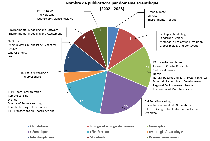
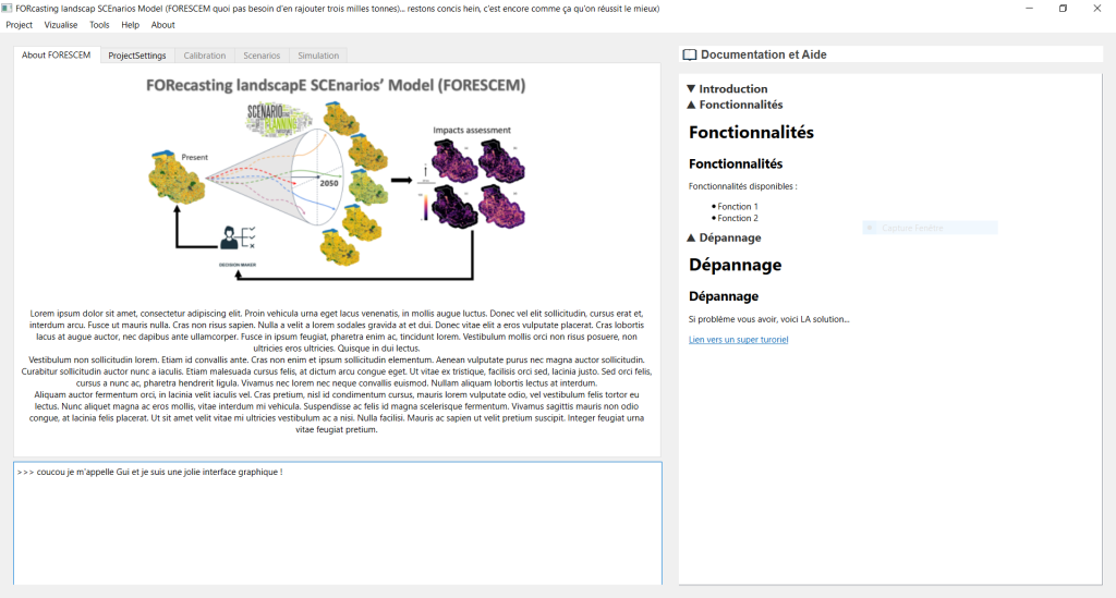
FORESCEM 1.0
Logiciel de simulation des changements d'occupation et d'usage du sol à partir de scénarios prospectifs.
Developers: G. Palka, T. Houet
Contact Email: thomas.houet[at]univ-rennes2.fr (thomas[dot]houet[at]univ-rennes2[dot]fr)
Program language: Python
Availability and cost: Command line freeware (including demo data set) for eductional and research only downloadable upon request. A User-friendly interface is under development - New Release Sept 2025.
References:
Houet T., Palka G., Rigo R., Boussard H., Baudry J., Poux X., Narcy JB., Alvarez Martinez JM., Balbi S., Mony C., Lecoq L., Beganton J., Barquin Ortiz J. (In press) European blue and green infrastructure network strategy vs. the common agricultural policy. Insights from an integrated case study (Couesnon, Brittany). Land Use Policy. https://doi.org/10.1016/j.landusepol.2022.106277
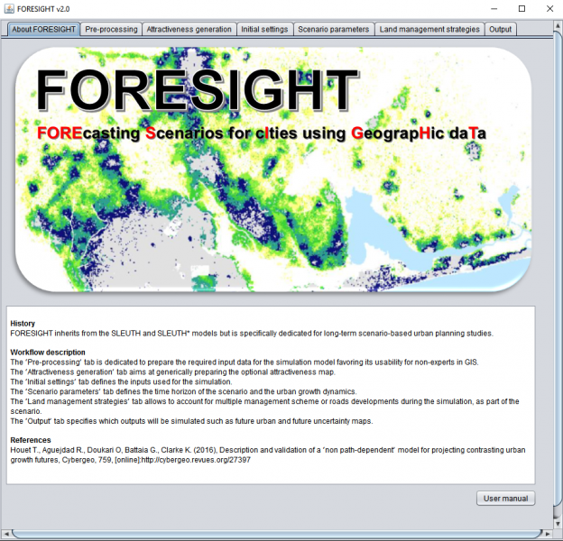
FORESIGHT v2.2.
Logiciel de simulation de l'étalement urbain à partir de scénarios prospectifs. Il s'agit d'une version avancée du logiciel SLEUTH* (pour experts et non-experts en SIG).
Developers: G. Battaia, T. Houet
Contact Email: thomas.houet[at]univ-rennes2.fr (thomas[dot]houet[at]univ-rennes2[dot]fr)
Software required: Java 8.0 or upgrade
Program language: C
Availability and cost: Freeware (including demo data set) for eductional and research only downloadable upon request
References:
Houet T., Aguejdad R., Doukari O, Battaia G., Clarke K. (2016), Description and validation of a ‘non path-dependent’ model for projecting contrasting urban growth futures, Cybergeo, 759, http://cybergeo.revues.org/27397
Doukari O., Aguejdad R., Houet T. (2016) SLEUTH* : un modèle d'expansion urbaine pour une approche scénario-dépendante. Revue Internationale de Géomatique, 1, 7-32. http://rig.revuesonline.com/articles/lvrig/pdf/2016/01/lvrig261p7.pdf
SHIELD - Simulating Herd Impact on Encroachment in upLanD (in prep)
Developers: Laure Vacquié, Thomas Houet, David Sheeren
Contact Email: laure.vacquie[at]gmail.com (laure[dot]vacquie[at]gmail[dot]com) (Laure Vacquié)
Hardware required: 32-bit or 64-bit PC with Windows 8, Windows 7, Vista, 2000 or XP; Mac OS X 10.6 or newer
Software required: Netlogo software (http://ccl.northwestern.edu/netlogo). MS Office Excel for modifying input files
Program language: Scala, Java
Availability and cost: Freeware (including demo data set) downloadable upon request
Reference publication: Vacquié L., Houet T., Sheeren D., de Munnik N., Roussel V., Waddle J., (2016) Adapting grazing practices to limit the reforestation of mountainous summer pastures: an agent-based model (SHIELD), Environmental Modelling and Software, 84:395-411, http://dx.doi.org/10.1016/j.envsoft.2016.05.006
DYPAL - DYnamic PAtchy Landscape modelling platform
DYPAL, short for DYnamic PAtchy Landscape modelling platform, is a convenient tool dedicated to ecologists (researchers) and landscape managers, and for educational purposes. On the one hand, DYPAL is able to simulate observed landscape dynamics to verify that these dynamics have been correctly understood, and to infer the most probable drivers for them. On the other hand, DYPAL provides a computer-aided projection of strategies in landscape ecology and environmental sciences.
Developers: C. Gaucherel
Software required: Java
Availability and cost: Freeware (including demo data set) downloadable here : http://amap-collaboratif.cirad.fr/pages_logiciels/index.php?page=downlo…
Reference publication:
Houet T., Schaller N., Castets M., Gaucherel C., (2014) Improving the simulation of fine scale landscape changes coupling top-down and bottom-up land use and cover changes rules. International Journal of Geographical Science. 28(9), 1848-1876, http://dx.doi.org/10.1080/13658816.2014.900775
Gaucherel, C., Boudon, F., Houet, T., Castets, M., Godin, C., (2012) Understanding Patchy Landscape Dynamics: Towards a Landscape Language. PLOS One, 7(9): http://journals.plos.org/plosone/article?id=10.1371/journal.pone.0046064
Gaucherel, C., Griffon, S., Houet, T., Misson, L. (2010) Combining process-based models for future biomass assessment at landscape scale. Landscape Ecology, 25 (2): 201-215.